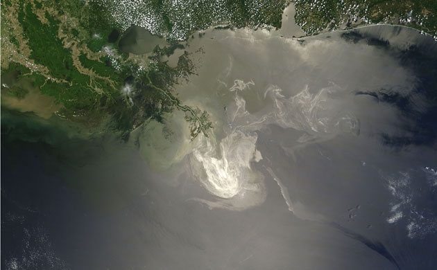
Satellite eye on Earth: May 2010 courtesy Guardian.Co.Uk / Nasa
Sunlight illuminates the lingering oil slick off the Mississippi delta on 24 May, 2010. In this image, oil smooths the ocean surface, making the Sun’s reflection brighter in some places, and reducing the scattering of sunlight in other places. As a result, the oil slick is brighter than the surrounding water in some places (image centre), and darker in others (lower right). The tip of the Mississippi delta is surrounded by muddy water that appears light tan. Bright white ribbons of oil streak across this sediment-laden water. A small, dark plume along the edge of the slick, not far from the original location of the Deepwater Horizon rig, indicates a possible controlled burn of oil on the ocean surface

This panorama was taken by an astronaut looking south-east across the South American continent when the International Space Station (ISS) was almost directly over the Atacama desert near Chile’s Pacific coast. The high plains (3,000–5,000 metres) of the Andes mountains appear in the foreground, with a line of young volcanoes (dashed line) facing the much lower Atacama desert (1,000–2,000m elevation). Several salt-crusted dry lakes occupy the basins between major thrust faults in the Puna. The largest of these, Salar de Arizaro, is seen in the foreground in this view. The Atlantic Ocean coastline, where Argentina’s capital city of Buenos Aires sits along the Río de la Plata, is dimly visible at image top left
Photograph: ISS/NASA

New eruptions from Iceland’s Eyjafjallajökull volcano have produced a 1,600km-wide ash cloud over the Atlantic. The brownish plume, travelling east and then south, is clearly visible in stark contrast to white clouds framing this Envisat image from 6 May 2010
Photograph: Envisat/ESA

ust plumes blew off the coast of Libya and over the Mediterranean Sea on 13 May, 2010. Thick dust blows northwards off the African coast, past the island of Kriti (Crete), and toward Peloponnisos (Peloponnese). In places, the dust is thick enough to completely hide the land or sea surface below. Source points for the dust storm are not obvious in this image, and the dust may have arisen far inland. More than 90% of Libya’s land surface is desert or semi-desert, and sand seas sprawl over much of the country’s arid interior
Photograph: MODIS/Aqua/NASA

On 24 May, 2010, the Advanced Spaceborne Thermal Emission and Reflection Radiometer on Nasa’s Terra satellite captured this false-colour, high-resolution view of the very tip of the Mississippi river delta. Ribbons and patches of oil that have leaked from the Deepwater Horizon well offshore are silver against the light blue colour of the adjacent water. Vegetation is red. In the sunglint region of a satellite image - where the mirror-like reflection of the Sun gets blurred into a wide, bright strip - any differences in the texture of the water surface are enhanced. Oil smooths the water, making it a better 'mirror'. Oil-covered waters are very bright in this image, but, depending on the viewing conditions (time of day, satellite viewing angle, slick location), oil-covered water may look darker rather than brighter
Photograph: Aster/NASA

Early in the dry season in Democratic Republic of Congo (DRC), on 13 May, 2010, Modis satellites detected hundreds of active fires - marked here with red dots - in southern DRC and north-eastern Angola, a sign that the agricultural burning season was in full swing. More than half of the gross domestic product of DRC comes from the agricultural sector, and fire is a key part of farming in most of Africa. People burn crop residue to clear fields after harvest, and forest and other natural vegetation to clear new land for farming. Fire is also used to drive game and grazing animals to new locations and to stimulate new growth in pastures. This annual burning has taken place for hundreds - possibly thousands - of years, and is not necessarily hazardous. But it can have a strong influence on air quality and public health, as well as on climate and natural resources
Photograph: MODIS/NASA

This image shows the straits of Florida, where the loop current flows eastward out of the Gulf of Mexico (visible west of Florida) before joining the Gulf Stream and flowing along the eastern coastlines of the US and Newfoundland
Photograph: MERIS/Envisat/ESA

 Galactic Images
 Re: Galactic Images
 Re: Galactic Images
 Re: Galactic Images
 Re: Galactic Images
 Re: Galactic Images
 Re: Galactic Images
 Re: Galactic Images
 Re: Galactic Images
 Re: Galactic Images
 Re: Galactic Images


 Re: Galactic Images
 Re: Galactic Images
 Re: Galactic Images
 Re: Galactic Images

 Re: Galactic Images
 Re: Galactic Images